
写在前面:
项目需求用到这个功能,主要目的是实现老师设置位置签到范围,学生在一定范围内进行签到的功能。
功能如下方截图:
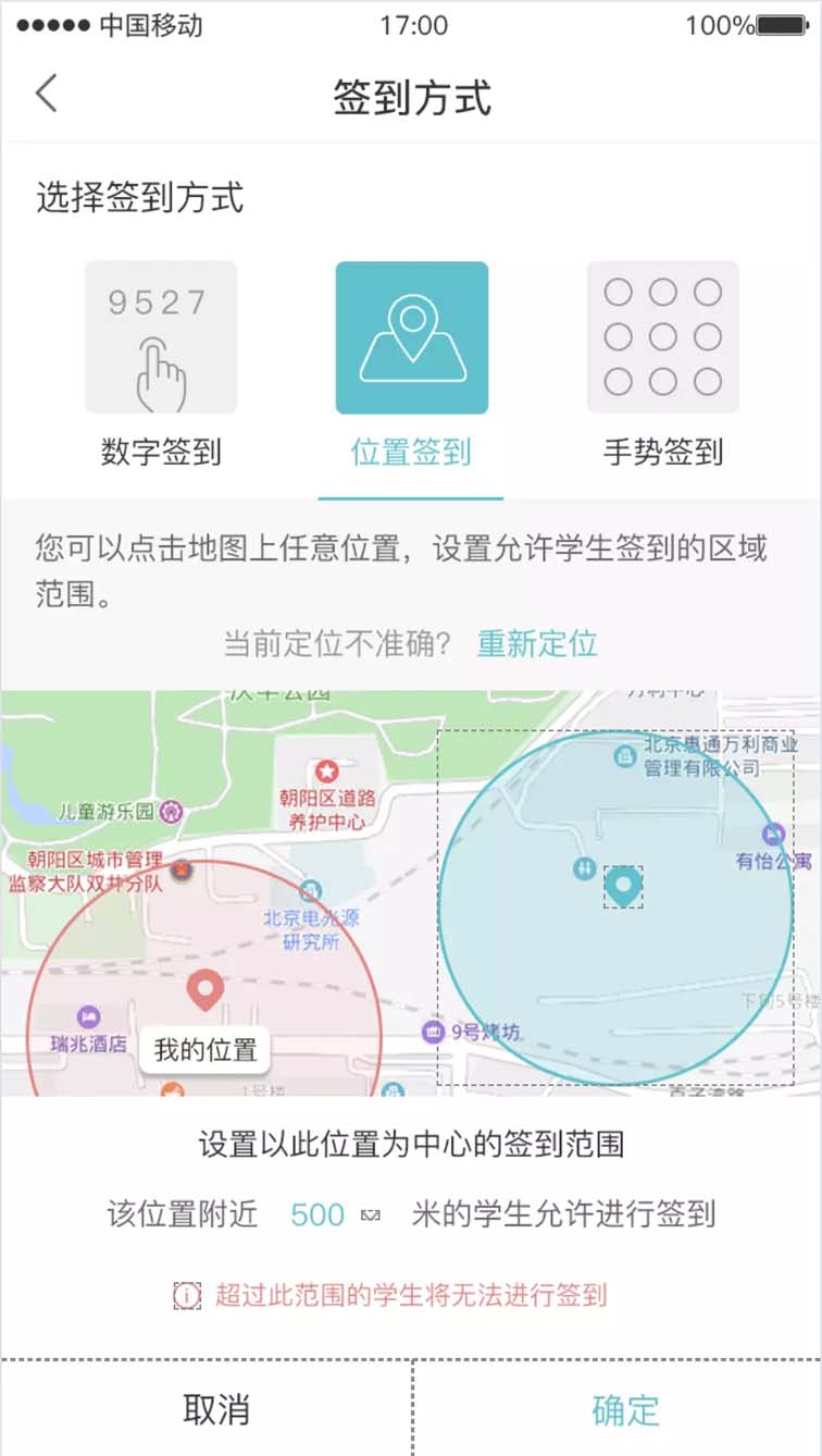
屏幕快照 2019-01-28 上午10.29.26.png
简要介绍:
下面记录一下主要的实现流程,功能的实现主要是根据百度地图开发者官网提供的api文档,各项功能之间组合。百度地图的sdk现在分成了地图功能和定位功能两块不同的sdk,baidumapapi这个是基础的地图功能,bmklocationkit这个是定位功能。项目里实现定位签到功能用的的sdk包括上面说的这两个模块,所以在用cocopods引入framework的时候,需要引入: #百度地图 pod 'bmklocationkit' pod 'baidumapkit'
功能实现
一、在appdelegate.m文件中引入:
|
1
2
|
#import <baidumapapi_base/bmkbasecomponent.h>
#import <bmklocationkit/bmklocationcomponent.h>
|
加入功能代码:
|
1
2
3
4
5
6
7
8
9
10
11
|
#pragma mark 百度地图设置
- (void)configbaidumap {
nsstring *ak = @"xxxx";
bmkmapmanager *mapmanager = [[bmkmapmanager alloc] init];
self.mapmanager = mapmanager;
bool ret = [mapmanager start:ak generaldelegate:nil];
[[bmklocationauth sharedinstance] checkpermisionwithkey:ak authdelegate:self];
if (!ret) {
nslog(@"manager start failed!");
}
}
|
二、在用到地图定位功能的viewcontroller中
|
1
2
3
|
#import <bmklocationkit/bmklocationcomponent.h>
#import <baidumapapi_base/bmkbasecomponent.h>//引入base相关所有的头文件
#import <baidumapapi_map/bmkmapcomponent.h>//引入地图功能所有的头文件
|
遵循协议<bmkmapviewdelegate,bmklocationmanagerdelegate>
声明全局变量
|
1
2
3
4
5
6
|
@property (nonatomic, strong) bmkuserlocation *userlocation; //当前位置对象
@property (nonatomic, strong) bmklocationmanager *locationmanager;/** locationmanager*/
@property (nonatomic, strong) bmkmapview *mapview;/** 百度地图*/
//@property (nonatomic, strong) bmkpointannotation* annotation ;/** 标记*/
@property (nonatomic, strong) nsmutablearray *annotationarr;/** 标记数组*/
@property (nonatomic, strong) nsmutablearray *circlearr;/** 圆形数组*/
|
地图sdk文档中建议在以下代码中如此设置, 目的是控制内存
|
1
2
3
4
5
6
7
8
9
10
11
12
13
14
15
16
17
|
- (void)viewwillappear:(bool)animated {
[super viewwillappear:animated];
[_mapview viewwillappear];
_mapview.delegate = self;
}
- (void)viewwilldisappear:(bool)animated {
[super viewwilldisappear:animated];
[_mapview viewwilldisappear];
_mapview.delegate = nil;
}
- (void)dealloc {
if (_mapview) {
_mapview = nil;
}
}
|
初始化数组,这两个数组在接下来会用到
|
1
2
3
4
5
6
7
8
9
10
11
12
13
14
|
- (nsmutablearray *)annotationarr {
if (!_annotationarr) {
_annotationarr = [nsmutablearray array];
}
return _annotationarr;
}
- (nsmutablearray *)circlearr {
if (!_circlearr) {
_circlearr = [nsmutablearray array];
}
return _circlearr;
}
|
添加地图view
|
1
2
3
4
5
6
7
8
9
10
11
12
13
14
15
16
17
18
19
20
21
22
23
24
|
#pragma mark 添加地图
- (void)addsignmapbgview {
if (!self.mapbgview) {
uiview *mapbgview = [uiview new];
self.mapbgview = mapbgview;
mapbgview.backgroundcolor = [commutls colorwithhexstring:app_bgcolor];
[self addsubview:mapbgview];
[mapbgview makeconstraints:^(masconstraintmaker *make) {
make.top.equalto(self.tipview.bottom);
make.left.right.bottom.equalto(0);
}];
_mapview = [[bmkmapview alloc] initwithframe:cgrectzero];
// _mapview.delegate = self;
[_mapview setzoomlevel:21];//精确到5米
_mapview.showsuserlocation = yes;//显示定位图层
[mapbgview addsubview:_mapview];
[_mapview makeconstraints:^(masconstraintmaker *make) {
make.edges.equalto(0);
}];
_mapview.usertrackingmode = bmkusertrackingmodenone;
}
}
|
|
1
2
3
4
5
6
7
8
9
10
11
12
13
14
15
16
17
18
19
20
21
22
23
24
25
26
27
28
29
30
31
32
33
34
35
36
37
38
39
40
41
42
|
#pragma mark 初始化locationmanager
- (void)inituserlocationmanager {
//因为mapview是在一个分离出来的view中创建的,所以在这里将signsettypeview中的mapview赋给当前viewcontroller的mapview;
self.mapview = self.mainview.signsettypeview.mapview;
self.mapview.delegate = self;
// self.annotation = [[bmkpointannotation alloc] init];
// self.mapview是bmkmapview对象
//精度圈设置
bmklocationviewdisplayparam *param = [[bmklocationviewdisplayparam alloc] init];
//设置显示精度圈,默认yes
param.isaccuracycircleshow = yes;
//精度圈 边框颜色
param.accuracycirclestrokecolor = [uicolor colorwithred:242/255.0 green:129/255.0 blue:126/255.0 alpha:1];
//精度圈 填充颜色
param.accuracycirclefillcolor = [uicolor colorwithred:242/255.0 green:129/255.0 blue:126/255.0 alpha:0.3];
[self.mapview updatelocationviewwithparam:param];
self.userlocation = [[bmkuserlocation alloc] init];
//初始化实例
_locationmanager = [[bmklocationmanager alloc] init];
//设置delegate
_locationmanager.delegate = self;
//设置返回位置的坐标系类型
_locationmanager.coordinatetype = bmklocationcoordinatetypebmk09ll;
//设置距离过滤参数
_locationmanager.distancefilter = kcldistancefilternone;
//设置预期精度参数
_locationmanager.desiredaccuracy = kcllocationaccuracybest;
//设置应用位置类型
_locationmanager.activitytype = clactivitytypeautomotivenavigation;
//设置是否自动停止位置更新
_locationmanager.pauseslocationupdatesautomatically = no;
//设置是否允许后台定位
//_locationmanager.allowsbackgroundlocationupdates = yes;
//设置位置获取超时时间
_locationmanager.locationtimeout = 15;
//设置获取地址信息超时时间
_locationmanager.regeocodetimeout = 15;
//请求一次定位
[self requestlocation];
}
|
请求定位,获取经纬度
|
1
2
3
4
5
6
7
8
9
10
11
12
13
14
15
16
17
18
19
20
21
22
23
24
25
26
27
28
29
30
31
32
33
34
35
36
37
38
39
|
#pragma mark 请求定位
- (void)requestlocation {
[_locationmanager requestlocationwithregeocode:yes withnetworkstate:yes completionblock:^(bmklocation * _nullable location, bmklocationnetworkstate state, nserror * _nullable error) {
if (error)
{
nslog(@"locerror:{%ld - %@};", (long)error.code, error.localizeddescription);
}
if (location) {//得到定位信息,添加annotation
if (location.location) {
nslog(@"loc = %@",location.location);
}
if (location.rgcdata) {
nslog(@"rgc = %@",[location.rgcdata description]);
}
if (!location) {
return;
}
if (!self.userlocation) {
self.userlocation = [[bmkuserlocation alloc] init];
}
self.userlocation.location = location.location;
[self.mapview updatelocationdata:self.userlocation];
cllocationcoordinate2d mycoordinate = location.location.coordinate;
self.mapview.centercoordinate = mycoordinate;
//赋予初始值
self.viewmodel.lat = [nsstring stringwithformat:@"%f", location.location.coordinate.latitude];
self.viewmodel.lng = [nsstring stringwithformat:@"%f",location.location.coordinate.longitude];
self.viewmodel.radius = @"50";
//打印经纬度
nslog(@"didupdateuserlocation lat %f,long %f",location.location.coordinate.latitude,location.location.coordinate.longitude);
}
nslog(@"netstate = %d",state);
}];
}
|
地图长按选点功能实现:
|
1
2
3
4
5
6
7
8
9
10
11
12
13
14
15
16
17
18
19
20
|
//长按地图选点
- (void)mapview:(bmkmapview *)mapview onlongclick:(cllocationcoordinate2d)coordinate {
if (self.annotationarr.count > 0) {
[mapview removeannotations:self.annotationarr];
[self.annotationarr removeallobjects];
bmkpointannotation *annotation = [[bmkpointannotation alloc]init];
annotation.coordinate = coordinate;
[self.annotationarr addobject:annotation];
[mapview addannotations:self.annotationarr];
} else {
bmkpointannotation *annotation = [[bmkpointannotation alloc]init];
annotation.coordinate = coordinate;
[self.annotationarr addobject:annotation];
[mapview addannotations:self.annotationarr];
}
//弹出半径选择框
[self showlocationselectradiusviewwithcoordinate:coordinate];
}
|
选点后弹出选择定位范围弹框
|
1
2
3
4
5
6
7
8
9
10
11
12
|
#pragma mark 弹出位置弹框
- (void)showlocationselectradiusviewwithcoordinate:(cllocationcoordinate2d)coordinate {
extraactlocationsignpopview *popview = [extraactlocationsignpopview new];
[popview show];
@weakify(self);
[popview.locatioonsuresignal subscribenext:^(nsstring *x) {
@strongify(self);
self.viewmodel.radius = x;
cgfloat radius = [x floatvalue];
[self circlewithcenterwithcoordinate2d:coordinate radius:radius];
}];
}
|
设置好定位点以及半径范围后绘制范围圈,开始的时候声明的circlearr在这里用来盛放添加的区域圆形,在添加新的圆圈的时候,将之前旧的移除,保证每次绘制的范围都是最新的,同理annotationarr也是这个功能,因为api有提供的- (void)addoverlays:(nsarray *)overlays;这个方法:/** *向地图窗口添加一组overlay,需要实现bmkmapviewdelegate的-mapview:viewforoverlay:函数来生成标注对应的view overlays 要添加的overlay数组 */
|
1
2
3
4
5
6
7
8
9
10
11
12
13
14
15
16
17
18
19
20
21
22
23
24
25
26
27
28
29
30
31
32
33
|
#pragma mark 添加区域圆形覆盖
- (void)circlewithcenterwithcoordinate2d:(cllocationcoordinate2d )coor radius:(cgfloat)radius {
nslog(@"coordinate lat %f,long %f",coor.latitude,coor.longitude);
//赋予点击选点值
self.viewmodel.lat = [nsstring stringwithformat:@"%f", coor.latitude];
self.viewmodel.lng = [nsstring stringwithformat:@"%f",coor.longitude];
if (self.circlearr.count > 0) {
[_mapview removeoverlays:self.circlearr];
[self.circlearr removeallobjects];
bmkcircle *circle = [bmkcircle circlewithcentercoordinate:coor radius:radius];
[self.circlearr addobject:circle];
[_mapview addoverlays:self.circlearr];
} else {
bmkcircle *circle = [bmkcircle circlewithcentercoordinate:coor radius:radius];
[self.circlearr addobject:circle];
[_mapview addoverlays:self.circlearr];
}
}
#pragma mark 重绘overlay
- (bmkoverlayview *)mapview:(bmkmapview *)mapview viewforoverlay:(id <bmkoverlay>)overlay{
if ([overlay iskindofclass:[bmkcircle class]]){
bmkcircleview* circleview = [[bmkcircleview alloc] initwithoverlay:overlay];
circleview.fillcolor = [uicolor colorwithred:33/255.0 green:196/255.0 blue:206/255.0 alpha:0.3];
circleview.strokecolor = [uicolor colorwithred:33/255.0 green:196/255.0 blue:206/255.0 alpha:1];
circleview.linewidth = 1.0;
return circleview;
}
return nil;
}
|
至此,在地图上选点进行签到功能基本实现,另外,关于 自定义的范围圆圈的颜色,边框大小都是可以自定义的,选点的标记也是可以自定义的,官方文档有说明
总结
以上就是这篇文章的全部内容了,希望本文的内容对大家的学习或者工作具有一定的参考学习价值,如果有疑问大家可以留言交流,谢谢大家对快网idc的支持。

相关文章


- ASP.NET自助建站系统的域名绑定与解析教程 2025-06-10
- 个人服务器网站搭建:如何选择合适的服务器提供商? 2025-06-10
- ASP.NET自助建站系统中如何实现多语言支持? 2025-06-10
- 64M VPS建站:如何选择最适合的网站建设平台? 2025-06-10
- ASP.NET本地开发时常见的配置错误及解决方法? 2025-06-10